
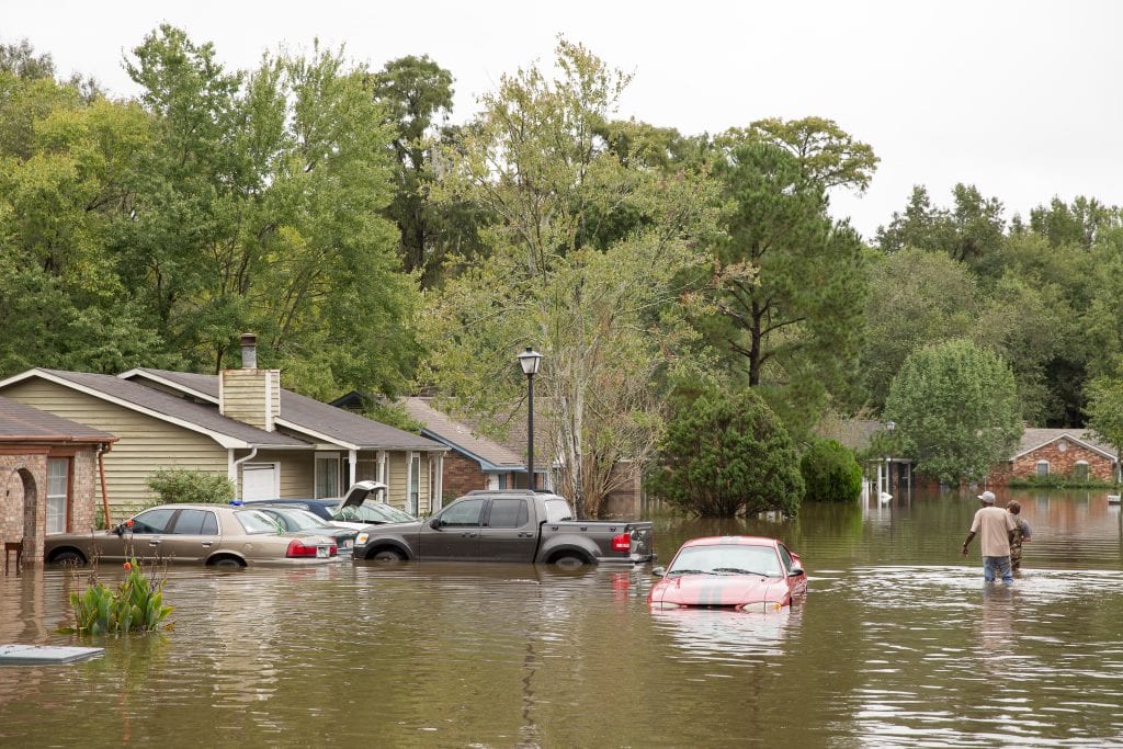
Across America, millions of families live in homes that are susceptible to flooding. And millions more could be at risk by the end of the century as the seas continue to rise and extreme weather events become more common. The National Flood Insurance Program (NFIP), for better or worse, plays a central role in the nation’s ability to address this growing threat.
Unfortunately, the federal flood insurance program has severe shortcomings—it has inaccurate and backward-looking flood maps, it’s not overly transparent about its flood risk and flood history data, and it doesn’t place enough emphasis on the importance of mitigation. These issues undermine everyone’s ability to accommodate and prepare for the damage wreaked to people’s homes by floods that are exacerbated by climate change. Homeowners and renters are left in the dark about their flood risk. This affects the community development field as well—affordable housing developers don’t have all the information they need to make siting and design decisions, and affordable housing lenders don’t have the information they need to appropriately underwrite flood-risk. This information gap distorts market signals, hinders fully informed decision making, and can lead to families being trapped in a nightmarish version of Groundhog Day: flooding, rebuilding, and repeating.
The maps for many areas that flooded when Superstorm Sandy struck in 2012 were last updated in 1983.
Congressional reform of the NFIP could help alleviate these problems, beginning with modernizing maps. Maps should be more granular and accurate in their risk assessment, and include predictive future flood conditions. Providing greater disclosure and transparency of flood risk data must be a top priority. The more information a person has, the better equipped they are to avoid living in a flood-prone home or to mitigate the risk of damage. The more information local governments, lenders, and developers have, the better they can shape resilient communities and protect vulnerable areas.
We Need Better Flood Maps
Congress enacted the NFIP to better protect the United States from flooding by providing a unified national program for floodplain management, which encompasses various preventive and corrective measures, such as building and zoning requirements, to reduce the risk of flood damage to development. The program not only provides access to insurance largely unavailable in the private market, but also promotes sustainable floodplain development and flood-risk identification. The program has three components—insurance, mapping, and appropriate building and land use regulations. All three are required for the program to function well.
Through the NFIP, FEMA provides flood maps for 22,000 communities across the United States. They provide the basis for both flood insurance rates and floodplain management regulations. The flood maps depict the areas that have at least a 1 percent annual chance of flooding (also called a “100-year floodplain”). FEMA’s minimum floodplain building and land use requirements apply only in these areas.
Federal flood insurance is only available to residents who live in communities that have adopted ordinances that include these requirements, which reduce the risk of flooding to people and property. One such building requirement is that new construction be elevated above the expected level of a 100-year flood. While building to flood-safe standards like these may raise construction costs, such costs are often offset by avoided flood damages and cheaper insurance.
Because of these requirements, FEMA’s maps are the standard nearly everyone turns to. Developers, emergency managers, and homeowners and buyers all rely on these maps for assessing and preparing for flood risk. If FEMA’s flood maps are not accurate, communities will be misinformed about their true flood exposure.
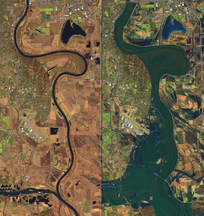
Unfortunately, a majority of FEMA’s maps are inaccurate and out of date. According to a September 2017 report by the Department of Homeland Security’s Office of Inspector General, FEMA was unable to “provide members of the public with a reliable rendering of their true flood vulnerability or ensure that NFIP rates reflect the real risk of flooding.” Per the report, almost two-thirds of FEMA’s flood maps had not been updated in the five years prior to the report’s publication. In addition, numerous communities had not had a map update in more than 30 years. For example, the maps for many areas that flooded when Superstorm Sandy struck in 2012 were last updated in 1983. A combination of inadequate funding mechanisms, lack of uniform policies and procedures, and poor oversight of mapping partners was to blame.
Flood maps must be updated because flood risk is not static; changes in hydrology, topography, and land development all have an impact on flood conditions. By law, FEMA must assess the need to revise and update flood maps at least once every five years.
Faulty information about an area’s flood risk leaves homeowners and renters vulnerable, especially if their residences aren’t listed in the 100-year floodplain. If flood maps are inaccurate, minimum building codes may only be applied in an area that’s smaller than the true 100-year floodplain, which would leave new construction vulnerable.
Up-to-date and accurate FEMA flood maps would benefit communities, developers, and households. However, such maps still would only provide a snapshot in time of risk. This is because almost all FEMA flood maps fail to identify and incorporate future conditions—predicted sea level rise, estimated changes in rainfall, or expected population growth—into their flood-risk projections. The flood maps currently being produced for the New York City region will be a rare exception, depicting how the region’s flood risk will change due to impending changes such as sea level rise. Under current FEMA standards for a flood-risk mapping, New York had to request the inclusion of future conditions and the city is working with the agency to produce those conditions on the maps.
To give an accurate representation of flood risk, FEMA must extrapolate future flood conditions everywhere, based on current trends and meteorological models. By 2100, the oceans could rise by as much as 9.8 feet along the East Coast, according to the latest projections from the National Oceanic and Atmospheric Administration. Three feet (0.9 meters) of sea level rise could affect the homes of 4.2 million Americans; a rise of six feet (1.8 meters) could affect 13.1 million.
Many areas are already experiencing the effects of sea level rise. Increased incidents of “sunny-day flooding” are becoming common. These floods are not caused by a hurricane or a storm, but by high tides. Places like Miami and Atlantic City are being repeatedly inundated by tidal flooding and will do so increasingly as sea levels become higher.
However, coastal communities are not alone in bearing the brunt of increased flooding. Riverine areas are also increasingly vulnerable. A study conducted by AECOM, a global engineering firm, found that many inland floodplains could expand in size, on average, by 45 percent by 2100, which would in turn greatly increase the number of vulnerable properties. If these changing flood dynamics are not taken into account, many families will be misled into thinking they are safe from flooding.
States and communities have undertaken efforts to produce their own maps due to a lack of decent alternatives. For example, North Carolina provides digitally accessible flood hazard data, models, maps, risk assessments, and reports to the public. North Carolinians can find out their flood risk simply by plugging their address into the mapping products search function to learn their flood zone, source of flood risk, and estimated cost of flood insurance. Indiana’s Floodplain Information Portal is another example. However, such endeavors are not universal.
In addition, according to recent Congressional testimony by the Association of State Floodplain Managers, many private sector flood risk assessment methods are not publicly available. And those private models often are based on data from FEMA’s flood maps, which raises questions about accuracy again.
Given the lack of widespread alternatives, ensuring FEMA flood maps are accurate and forward-looking is paramount for making decisions about where and what to build.
People Should Not Be Kept in the Dark
Accurate and forward-looking flood maps are just one part of the safety equation, however. All residents, as well as lenders and developers, should have a right to know more than just whether a property is inside a mapped flood zone. They should also have a right to know a property’s flood history, flood insurance requirements, and post-flood building requirements, such as whether local laws could require the property to be elevated if it suffers substantial flood damage. Unfortunately, this information is not easy to access; how easy often depends on where one lives.
In too many states, homebuyers and renters are not told about a property’s flood history. Often, buyers only learn that a property has flooded in the past at closing if it comes up when their lender notifies them that they need to buy flood insurance based on the FEMA flood maps. Others only learn after their new home is flooded, and they discover it isn’t the first time. For renters, the situation is even more murkier.
Inadequate disclosure laws mean far too many Americans have zero knowledge of whether the biggest financial investment of their lives has ever flooded or is likely to flood again.
Twenty-one states lack any statutes or regulations that require a seller to disclose a property’s history of flood damages to a buyer. In addition, sellers are not required to disclose either a property’s flood insurance requirements or the cost of that insurance. The other 29 states, plus Washington, D.C., have a smorgasbord of partial disclosure requirements, many of which fall short of enabling buyers to make a fully informed decision.
Inadequate disclosure laws mean far too many Americans have zero knowledge of whether the biggest financial investment of their lives has ever flooded or is likely to flood again. More than 100,000 properties insured through the NFIP have flooded more than once. This problem could be solved simply by having access to information—information that the seller of the home may have and should be required to provide.
Such disclosure and transparency provisions should also not be limited to disclosure requirements imposed on sellers. The NFIP must also improve the information that is available to the public. Current homeowners who do have not the luxury of living in a state with good flood-hazard disclosure laws should have a right to know about their property’s flood risk. This should include any past history of flood insurance coverage, damage claims paid, and whether there is a legal requirement to purchase flood insurance because of past owners’ receipt of federal disaster aid. This is information that FEMA should have if a property was ever covered by the NFIP, and it should make it public and easily searchable by address.
In addition, FEMA should provide greater access to a community or region’s flood risk information, such as aggregate claims and policy history, repeatedly flooded areas, and whether NFIP-participating communities are complying with the requirements of the program.
While thorough disclosure and transparency requirements could unintentionally burden current homeowners, to do otherwise only perpetuates the problem, creating a dangerous game of musical chairs where eventually someone is stuck with a dangerous flood-prone property.
To counter this problem, more mitigation assistance must be made available to help those already living in flood-prone homes—especially low-income households—reduce their flood risk. For example, Congress should increase the amount of money provided under the Increased Cost of Compliance (ICC) program. Currently, the program provides up to $30,000 per property to help cover the cost of paying for mitigation measures that will reduce flood risk. In addition, the types of eligible mitigation activities under the ICC program should be expanded, including paying for voluntary buyouts. No one should have to learn they unknowingly placed their family in harm’s way because they were not told about a property’s flood history.
The Time for NFIP Reform Is Now
Given the NFIP’s centrality to the nation’s floodplain management practices, including its influence over building and land use decisions, Congress has a duty to reform the program to ensure Americans are not increasingly placed in harm’s way as the threat of flooding continues to grow. Congress should enact the following recommendations to ensure that the NFIP protects people and property, acting as a benefit not a burden:
- As a condition of NFIP participation, states should adopt comprehensive flood-hazard disclosure requirements for real estate transactions that provide homebuyers and renters with a right to know about a property’s history of flood damages, flood insurance coverage requirements, and whether the property is located in a flood zone.
- Provide homeowners with a “right to know” about their property’s history of flood insurance coverage, damage claims paid, and whether there is a legal requirement to purchase flood insurance because of past owners’ receipt of federal disaster aid.
- Create a public, open-data system to share information related to flood-damage claims, the number of repeatedly flooded properties, and whether communities are properly enforcing local building and zoning codes required under the NFIP. However, such information should be aggregated at a census or ZIP code level to respect privacy rights.
- Ensure that flood maps depict how sea level rise and other climate change impacts will affect future flood risk and ensure that data is easily accessible.
Congress has until May 31 to act before the program expires, a deadline it has continually punted for almost two years. Whether Congress will miss its target again is anybody’s guess. Yet as floods become more frequent and severe, the nation—and more specifically, those who are affected by flooding—do not have the luxury of letting history repeat itself.
Editor’s Note: This article has been updated to reflect the House vote to extend NFIP.


Also important to this issue is ensuring that flood insurance does not become another cost burden to low-income homeowner and renters (landlords could push the cost of flood insurance down to renters). The NFIP should continue to be subsidized by the government.